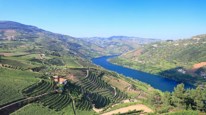
The Douro Valley is a UNESCO World Heritage Site because its vineyards, wine estates and villages record some 2,000 years of winemaking. In 2001, UNESCO recognized the Alto Douro Wine Region as a cultural landscape. The people who grew grapes here shaped the very hillsides you see today.
Look across the river at Pinhão and you’ll see row after row of vines curving around the hills. Up close, one of those rows might be just wide enough for a grape picker and a basket. How did growers turn slopes like these into wine country? A few details are worth looking for when you visit.
Which part of the Douro Valley is a World Heritage Site?
The official name on the World Heritage List is the Alto Douro Wine Region. It covers 24,600 hectares in northern Portugal, following sections of the Douro and its tributaries. A further 225,400 hectares form the surrounding buffer zone. The river valley itself extends well beyond the listed landscape.
Peso da Régua and Pinhão are useful places to start exploring. Between them, you can see the vineyards from river level, then head uphill toward a wine village and look back at the same slopes. A terrace that looked like a pencil line from the river becomes a wall tall enough to stand beside.
What were UNESCO’s three reasons for listing the region?
UNESCO used three cultural criteria. Each gives you something different to look for on a visit.
- A long winemaking tradition (criterion iii): families have grown grapes here for around two millennia. A hillside worked over generations preserves evidence of that history in its walls and planting patterns;
- A landscape built around wine (criterion iv): follow a lane from a terrace to a quinta, or wine estate, and on to the village. The vineyards, farm buildings, roads and chapels show how work, trade and community life fitted together;
- A European wine region that keeps evolving (criterion v): different generations found different ways to plant on these slopes. Old stone terraces and newer vineyards still share the same working landscape.
How do you tell the different vineyard terraces apart?
Start by looking at what holds up each row. Traditional socalcos have retaining walls built from pieces of local schist. Some of the oldest terraces are narrow and irregular, with room for only one or two rows of vines. Building the ledge was only the beginning. Growers also had to keep the wall sound so the soil would stay on the slope.
In the late 19th century, phylloxera, an insect that attacks vine roots, devastated many vineyards. As growers replanted, they built wider terraces. On more recently planted slopes you may also see patamares, terraces supported by banks of earth, or vinha ao alto, where the vine rows run straight up and down the hill. Try spotting two patterns from the same viewpoint.
What did Port wine change along the river?
In 1756, Portugal began formally demarcating the vineyards that could supply the Port wine trade. Grapes grew inland, while much of the wine traveled downstream in barrels. Flat-bottomed wooden boats called rabelos carried them to the cellars of Vila Nova de Gaia, across the river from Porto.
That journey helps explain why an estate might have vineyards high on the hill and buildings close to the water. In Peso da Régua, the Douro Museum occupies the former headquarters of the company that regulated the trade. It’s a good first stop if you want to understand how the wine reached buyers before you visit the places where it was grown.
Where can you see this heritage up close?
Allow time for a village, a stretch of river and a walk above the vines. Around Pinhão, you can see all three and compare the workers’ view of the landscape with the view from the water.
Start with the tiles at Pinhão station
At the railway station in Pinhão, look for the blue-and-white azulejos showing the grape harvest. Notice how the workers carry their baskets. Then look at the hills outside the station and imagine making that trip from the upper rows several times a day.
If you want to arrive by rail, our Porto and the Douro Valley Rail and Hike Tour pairs the Régua-Pinhão train journey with a walk at Quinta das Carvalhas. You see the terraces first from the carriage window and then from inside a working estate.
Follow the vineyard paths from Provesende
Provesende sits above the river, with manor houses and vineyard lanes that help put the wealth of the wine trade in context. Our Douro Wine Region self-guided hike tour follows old stone paths between Sabrosa, Provesende and Pinhão. On the descent toward the river, pause where a bend lets you look along a wall. From that angle you can see how carefully its stones follow the contour of the hill.
These vineyards are working farms. Stay on the marked route and arrange a visit with the estate if you’d like to step into the rows or explore a cellar.
When is a good time to explore the wine landscape?
Spring makes for a rewarding vineyard walk as fresh growth traces the rows. Around the Douro Valley harvest season, the focus shifts to picking. Dates vary by estate, grape variety and weather. If you want to watch the harvest or try grape treading, contact the quinta ahead of time to find out what it offers that year.
Whatever the season, leave time for one stretch on foot. From a viewpoint, the Douro’s terraces make a striking pattern. Beside a schist wall, you can pick out the individual stones that somebody carried, fitted into place and kept in repair. That’s where the World Heritage story comes into focus.